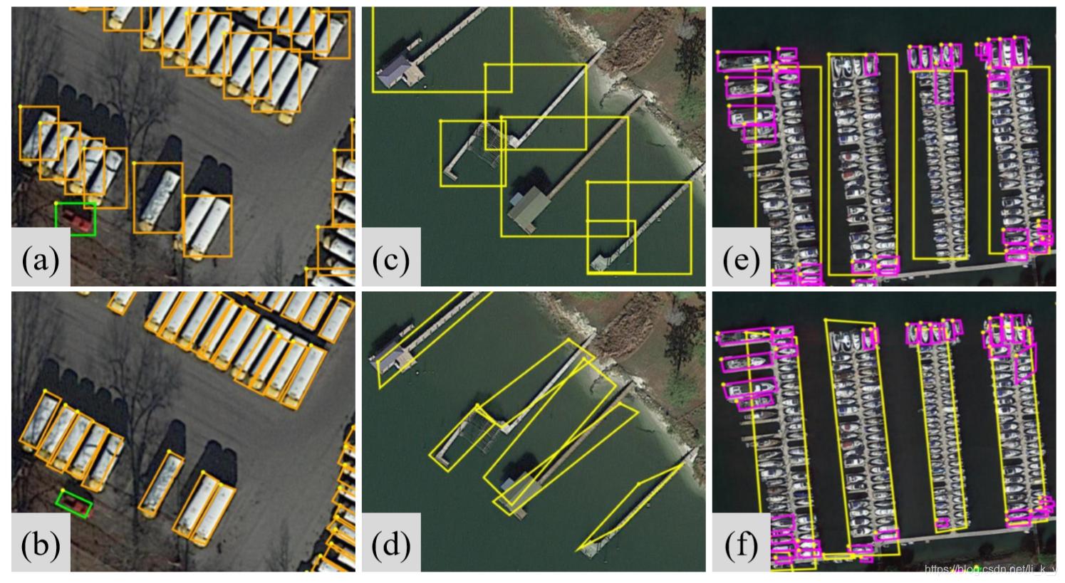
DOTA v2.0
The industry-standard benchmark for oriented object detection in aerial imagery. It features complex spatial annotations and addresses the challenges of multiscale object detection in remote sensing.
- Modality: Optical Remote Sensing
- Scale: 1.79M instances, 18 categories
- Key Strength: Standardized OBB evaluation
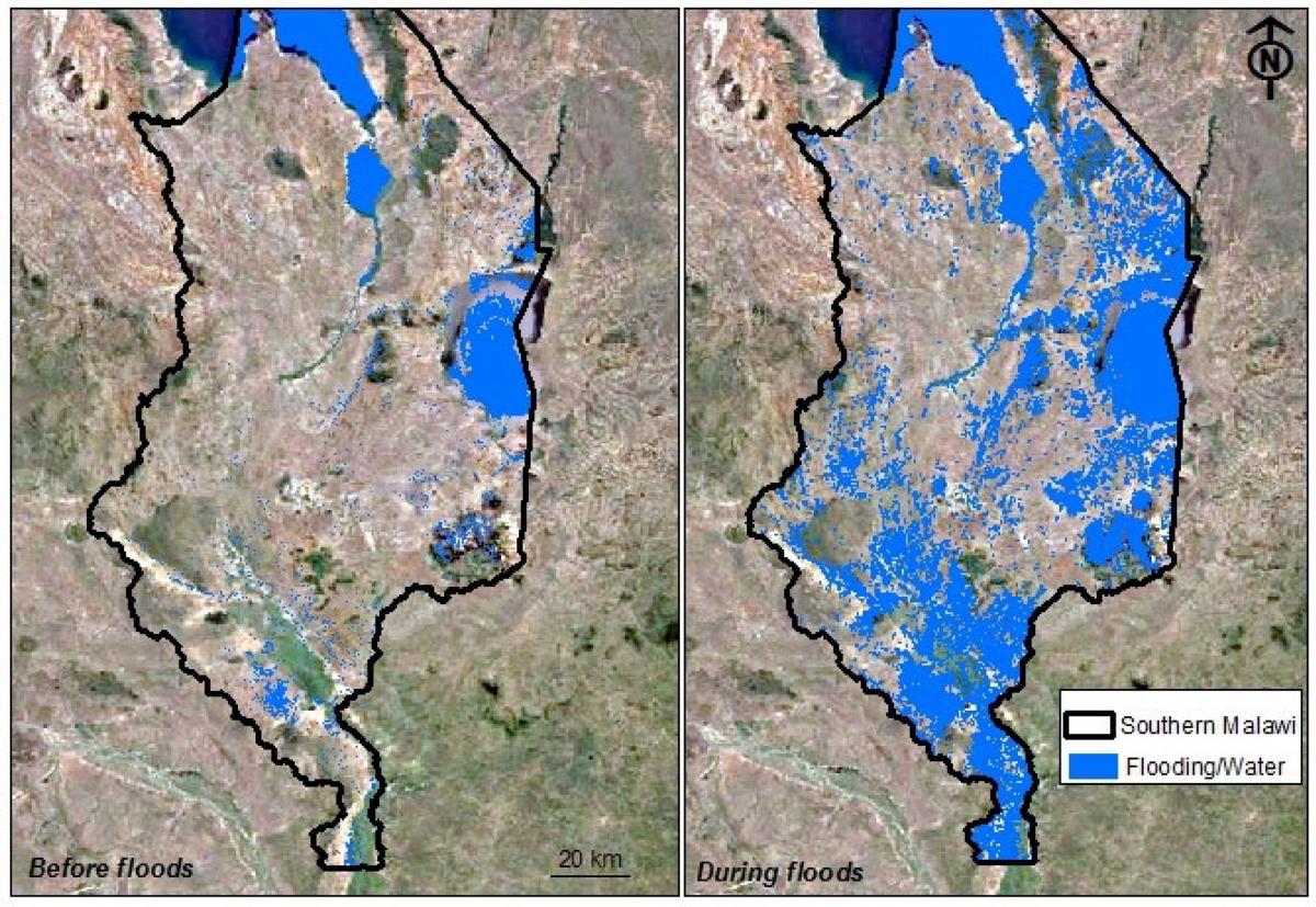
Kuro Siwo
A massive, global multi-temporal SAR dataset designed for flood mapping, enabling all-weather analysis of water surface changes during disasters.
- Modality: Sentinel-1 SAR
- Scale: 43 global flood events
- Key Strength: Multi-temporal flood analysis
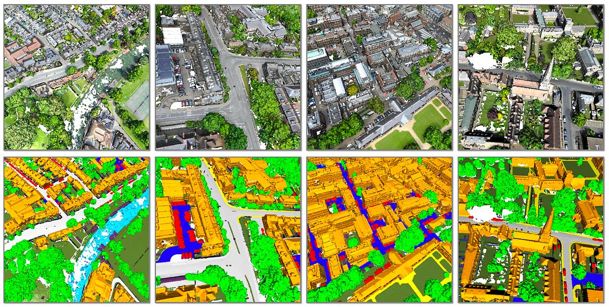
SensatUrban
A large-scale urban point cloud dataset providing dense 3D representations of city environments for semantic segmentation and digital twin applications.
- Modality: Photogrammetric Point Cloud
- Scale: Large-scale urban scenes
- Key Strength: Fine-grained 3D semantic labels
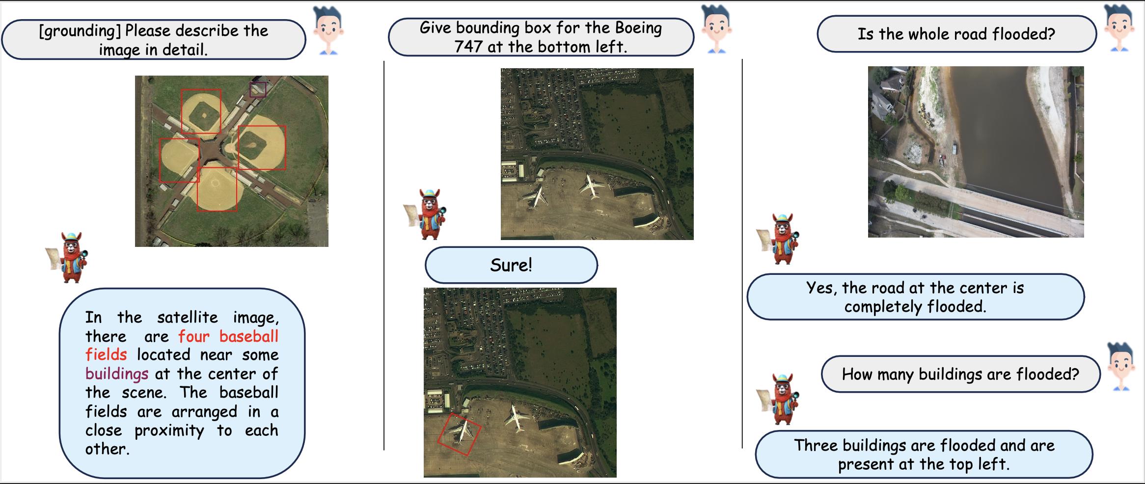
GeoChat-Instruct
A large-scale instruction-following dataset for remote sensing vision-language models, enabling grounded conversations, reasoning and visual question answering over satellite imagery.
- Modality: Vision-Language
- Scale: 318K instruction pairs
- Key Strength: Grounded multimodal reasoning
Geospatial AI Datasets
This taxonomy covers Multi spectral, Multi temporal earth observation satellite data, raster data, vector data, point clouds, attribute/statistical information for land use land cover mapping, object detection, urban heat Island, transportation studies, traffic, agriculture, epidemiology, weather climate and vision language models and competition data.
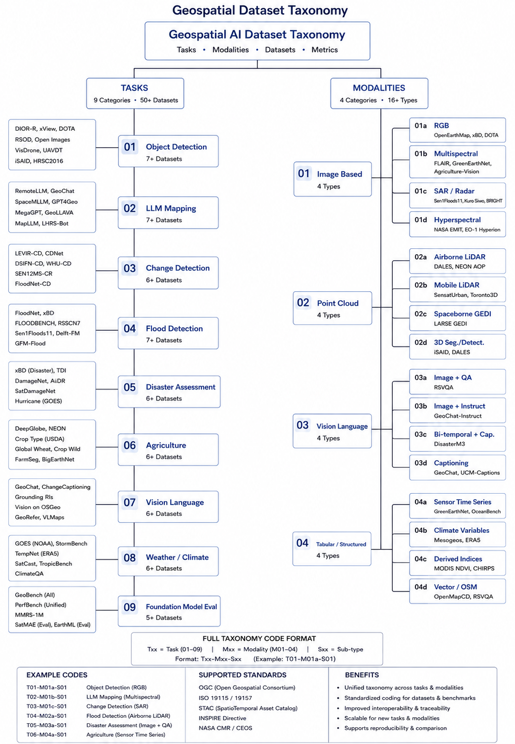
Master Dataset Directory
The complete curated list of state-of-the-art geospatial datasets across all modalities.
| Theme | Dataset Name | Potential Applications | Resolution | Venue (Year) | Link |
|---|---|---|---|---|---|
| Optical Imagery | DOTA v2.0 | Aerial object detection, oriented bounding box detection, multi-scale detection | 0.1–1.0m | CVPR (2021) | Data ↗ |
| Optical Imagery | DIOR | Object detection, few-shot detection, multi-class aerial recognition | 0.5–30m | ISPRS Journal (2020) | Data ↗ |
| Optical Imagery | iSAID | Instance segmentation, panoptic segmentation, aerial scene understanding | Sub-meter to 1m | CVPR Workshops (2019) | Data ↗ |
| SAR Imagery | SAR-AIRcraft-1.0 | SAR aircraft detection, fine-grained recognition, all-weather surveillance | 1m | IEEE TGRS (2023) | Data ↗ |
| Optical Imagery | OpenEarthMap | Land cover mapping, semantic segmentation, domain adaptation | 0.25–0.5m | WACV (2023) | Data ↗ |
| Multispectral | FLAIR | Semantic segmentation, multi-source fusion, super-resolution guided segmentation | 0.2m / 10m | NeurIPS D&B (2023) | Data ↗ |
| Optical Imagery | LoveDA | Domain adaptation, semantic segmentation, urban vs rural transfer | 0.3m | NeurIPS D&B (2021) | Data ↗ |
| Synthetic Imagery | SyntheWorld | Synthetic data augmentation, sim-to-real transfer, building change detection | Sub-meter | WACV (2024) | Data ↗ |
| SAR + Optical | OpenEarthMap-SAR | All-weather mapping, SAR-optical fusion, segmentation | Sub-meter to 10m | NeurIPS D&B (2024) | Data ↗ |
| Optical Imagery | Globe230k | Global land cover classification, climate modeling inputs | 30m | Journal of Remote Sensing (2023) | Data ↗ |
| SAR Imagery | Kuro Siwo | Flood mapping, rapid disaster response, SAR time-series analysis | 10m | NeurIPS D&B (2023) | Data ↗ |
| SAR Imagery | Sen1Floods11 | Flood inundation mapping, SAR semantic segmentation, weak supervision | 10m | CVPR Workshops (2020) | Data ↗ |
| UAV Imagery | FloodNet | Post-flood scene understanding, VQA, semantic segmentation | ~5cm | IEEE Access (2021) | Data ↗ |
| SAR + Optical | AllClear | Cloud removal, image reconstruction, data fusion, time-series gap-filling | 10–30m | NeurIPS (2024) | Data ↗ |
| Optical Imagery | LEVIR-CD | Building change detection, urban expansion monitoring | 0.5m | IEEE TGRS (2020) | Data ↗ |
| Optical Imagery | WHU-CD | Building change detection, post-disaster reconstruction monitoring | 0.2m | IEEE TGRS (2019) | Data ↗ |
| Optical Imagery | xBD | Building damage classification, disaster response, change detection | 0.3–0.8m | CVPR Workshops (2019) | Data ↗ |
| Optical + Vector | OpenMapCD | Map updating, OSM-guided change detection, multimodal fusion | 0.25–0.5m | IEEE GRSL (2024) | Data ↗ |
| SAR + Optical | BRIGHT | Building damage assessment, multimodal fusion, all-weather disaster response | Sub-meter | CVPR (2025) | Data ↗ |
| UAV Imagery | RescueNet | Disaster damage segmentation, search and rescue planning | ~5cm | Scientific Data (2023) | Data ↗ |
| Vision-Language | DisasterM3 | Disaster VQA, damage description generation, multimodal disaster assessment | Sub-meter | arXiv (2025) | Data ↗ |
| Optical + NIR | Agriculture-Vision | Agricultural pattern recognition, crop health monitoring, precision agriculture | ~10cm | CVPR (2020) | Data ↗ |
| Multispectral | WeedsGalore | Weed detection, precision agriculture, UAV-based crop monitoring | Very high (UAV cm-level) | WACV (2025) | Data ↗ |
| Tabular + Raster | Mesogeos | Wildfire prediction, fire spread modeling, risk assessment | 1km | NeurIPS D&B (2023) | Data ↗ |
| Tabular + Raster | OceanBench | SSH interpolation, ocean current modeling, climate monitoring | ~25km | NeurIPS D&B (2023) | Data ↗ |
| Optical + Tabular | SatBird | Species distribution modeling, biodiversity mapping, conservation planning | 10m | NeurIPS D&B (2023) | Data ↗ |
| Optical + Climate | GreenEarthNet | Vegetation dynamics forecasting, drought impact, carbon flux estimation | 10m / 27km | CVPR (2024) | Data ↗ |
| Vision-Language | GeoChat-Instruct | Remote sensing VQA, grounded conversation, scene description, change captioning | Sub-meter to 10m | CVPR (2024) | Data ↗ |
| Vision-Language | RSVQA | Visual question answering, natural language remote sensing | 0.1–10m | IEEE TGRS (2020) | Data ↗ |
| Multi-Sensor | PANGAEA | Foundation model evaluation, transfer learning, multi-task geospatial AI | Varies (10m to 1km) | NeurIPS (2024) | Data ↗ |
| SAR + Optical | IEEE GRSS DFC 2024 | Flood detection, multi-source data fusion, operational flood mapping | 10m | IEEE GRSS (2024) | Data ↗ |
| Optical + Point Cloud | IEEE GRSS DFC 2023 | 3D building reconstruction, urban digital twin, height estimation | Sub-meter | IEEE GRSS (2023) | Data ↗ |
| Point Cloud | SensatUrban | 3D semantic segmentation of urban areas, digital twin modeling | Dense Point Cloud | CVPR (2021) | Data ↗ |
| Point Cloud | DALES | Aerial LiDAR semantic segmentation, urban infrastructure mapping | 0.5m spacing | CVPR EarthVision (2020) | Data ↗ |
| Vector Data | Overture Maps | Global mapping, POI analysis, routing, 3D building modeling | Vector Geometry | Overture Foundation (2023) | Data ↗ |
| Vector + Optical | SpaceNet 2 | Building footprint extraction, polygonization, urban planning | 0.3m (Raster) / Vector | SpaceNet (2017) | Data ↗ |